
Slieve Commedagh, standing tall at 767 meters above sea level, is the second-highest peak in Northern Ireland, with only Slieve Donard surpassing it. Located within the iconic Mourne Mountains, its name originates from the Irish Sliabh Coimhéideach, meaning “mountain of guarding or watching.” Nestled beside the famous Slieve Donard, this mountain offers breathtaking landscapes and intriguing geological features that make it a favorite for hikers and adventurers alike.
Despite numerous attempts to enjoy the panoramic views from Slieve Commedagh, we have often been met with dense low cloud cover obscuring the vistas. However, the challenge and adventure of this hike remain a rewarding experience.
The Slieve Commedagh Route
Our hike involved climbing a total of 1,047 meters in elevation while covering just over 18 kilometers in horizontal distance. Starting at Donard Park, we followed the Glen River trail toward Slieve Donard. The journey began with poor visibility, though we held out hope for better conditions based on an optimistic weather forecast.
Upon reaching the Donard Saddle, we veered toward Slieve Commedagh’s summit. The snow that lingered from recent weather added an extra layer of excitement as we slid down toward Slieve Corragh.
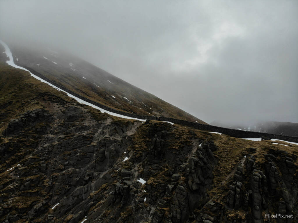
The Castles of Slieve Commedagh
One of the highlights of Slieve Commedagh is the Castles of Commedagh, a striking series of granite tors along its slopes. These natural formations are a geological marvel, carved by centuries of weathering and erosion. Determined to document their beauty, I attempted to capture footage despite the challenging conditions.
As the clouds briefly lifted, I managed to film a few clips, though the resulting video felt rushed and lacked the composition I had hoped for. Nevertheless, the footage offers a glimpse into the rugged charm of the Mournes.
Slieve Commedagh, Slieve Corragh, and Slievenaglogh
The weather gradually improved, allowing us to deploy the Mavic Air drone for short flights. Capturing low-level footage of the Castles of Commedagh, along with views of Ben Crom and Slieve Bearnagh, was a thrilling experience. All photos were processed using Lightroom with FlixelPix Lightroom Presets for enhanced detail and vibrancy.
While I remain cautious with drone flights, the still images captured during this hike hint at the area’s natural beauty. With practice, I hope to focus more on shot composition and less on the mechanics of flying.
The Descent and Return
As we continued our journey toward Slievenaglogh, the temperature dropped, and we made a careful descent to the famous Hare’s Gap. From there, the hike followed the Brandy Pad, a historic route once used by smugglers, but visibility remained poor.
Navigating back to the saddle between Slieve Commedagh and Slieve Donard in near-zero visibility was challenging, but the sense of accomplishment was undeniable. We pressed on through Donard Wood, where the weather cleared, offering a final reward of picturesque views as we descended to Donard Park.


Drone Footage and Lessons Learned
Despite the limited opportunities for aerial footage, the Mavic Air drone captured some memorable scenes, albeit with room for improvement in composition and technique. The snow-covered slopes of Slieve Commedagh and the surrounding peaks provided a dramatic backdrop, especially the views across the Castles of Commedagh, toward Ben Crom, and Slieve Bearnagh.
Slieve Commedagh Conclusions
This hike through Slieve Commedagh and its neighbouring peaks offered a mix of challenges and stunning scenery. The slide down the snowy slopes of Commedagh was a particular highlight, adding a sense of playfulness to an otherwise demanding trek.
While the weather didn’t always cooperate, it’s a reminder that the Mourne Mountains hold beauty and adventure regardless of the conditions. Whether you’re there to hike, explore, or capture stunning footage, Slieve Commedagh is a must-visit for any outdoor enthusiast.
Links
Slieve Doan, Central Mournes
10 Locations to visit in Northern for Photography
The Long Exposure eBook
Photographs of the Mourne Mountains
Instagram

Discover more from FLIXELPIX
Subscribe to get the latest posts sent to your email.